
A classic view of the "tofu" portion of the Pioneer Valley, looking south from Mt Sugarloaf in South Deerfield. The Mt Tom range is on the far right, the Conn. River gap next, and the Holyoke Range in center and left. The M-M Trail follows this bumpy ridge. Beyond the Range is Holyoke and Springfield.

Since I knew this was a long, 6+ mile section with many views, we waited until a picture perfect day and had Elizabeth drop us off during her lunch hour and pick us up after work. She left us at an old cemetery on Route 47 with great old headstones. One of the joys of rural cemeteries is that the headstones haven't been as eroded by pollution as they've been in urban areas like Philadelphia. Among the earliest we found was this gem with its great carvings and off-hand details about the deceased:

Unfortunately, the road where we were dropped off is .7 miles from the beach on the river where the trail picks up, which would cause us to walk it and back, but when we attempted to find the route between the river and road, we were met with a phalanx of "no trespassing" signs and no indication of a used pathway where the guidebook map had the line drawn. So, with daylight burning, we decided to skip that .7 mi of the M-M, and carry on. The long ascent up Mt Holyoke began almost immediately.

A couple nice views as we climbed, including this one looking south. Springfield is on the left side, Holyoke's spires are closer, to the right of the water tower, and Hartford's skyline is on the horizon above Hoyoke.

Looking north from a hang glider launch site towards the summit gives a view of the fertile floodplains of the Conn. River, Northampton beyond and the background Berkshire foothills.

Even more than on Mt Tom, the views from Mt Holyoke really show the entire valley, north and south. Landscape painters in the first half of the 19th Century discovered this and dragged easels and paints up to make sketches of the surrounding countryside. The most famous artwork to come of this was Thomas Cole's The Oxbow. Cole was the father of the Hudson River School movement, and sought to display American landscapes as grandiose, just like Europe's, but with a healthy dose of the sublime - the awesome and dangerous power of raw nature.

In "The Oxbow" view from the summit of Mt Holyoke, which is now obscured by trees, Cole paints the left half as a wave of raw nature with gnarled trees and rocky crags of the mountaintop stretching up into a terrific storm. Below lies the pastoral tranquility of the settled valley and Northampton gathered around the gentle sweep of the river. Cole titled the painting as a view "after a Thunderstorm", not before, and so the logging scars in the exaggerated background hills begin to talk about the kind of storm he may is referring to.
Funnily enough, a storm four years after he painted this in 1836 did cause the Connecticut to break through the narrow neck of the oxbow, straightening the river to its current course.
Our look around from the summit:
When Thomas Cole summitted Holyoke, there was a small cabin and a small house that a couple of entrepreneurs had built to serve drinks and other treats to visitors attracted to the views. Already, whatever wilderness that was left on the mountain was succumbing to tourism. Hiking trails were being developed by the local colleges (the ladies of nearby Mt. Holyoke College began their annual Mountain Day in 1837, which immediately attracted the young men of Amherst College to built trails up their side), and a carriage road to the top was constructed in the 1840s. By 1851, a pair of investors bought the mountain top and erected a two story, eight-room hotel, which was so successful they tripled its size ten years later. This building still exists as today's Summit House, making it one of (if not the oldest) the few mountain top hotels in the US still in existence.
Here's a view of the place in 1894, after an enormous addition was added:


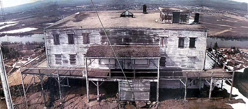
The building and mountain passed ownership a few times as the era of mountaintop vacations ended, and eventually wealthy Holyoke industrialist and conservationist Joseph Skinner picked it up in 1916 to prevent the mountain from being logged and mined and otherwise ruined. After the hurricane, he gave the Summit House and mountain property to the State of Massachusetts for a State Park in return for naming the new park after him. Thus, we have today's Skinner State Park. The state hasn't always been the best steward as this image of the building from 1976 shows:
The State eventually restored the building in the 1980s. There's construction this summer to repaint the building and make the place ADA-compliant by adding a wheelchair accessible ramp to the viewing deck, so it was not open to us. It is supposed to reopen in October, so we shall have to return for foliage season.
Thankfully, the beautiful picnic area to the east, once home to tennis courts and croquet lawns, is still open and very inviting. It made a perfect rest stop wher Peanut could run around and climb on "big woks".

Today two state parks - Skinner and Holyoke Range State Parks - encompass the entire Holyoke Range, though less than half the land within the park boundaries is actually owned by the State. During the late 1960s/early 70s, the Federal government was interested in creating a National Recreation Area centered on the range, though this fell through due to local opposition and other reasons. Here's a map of the proposed Natl Park Service unit:

http://www.chronos-historical.org/mtholyoke/
Past Mt Holyoke and its Summit House, the M-M Trail wanders up and down a rollercoaster of viewless summits called the "Seven Sisters" - though I lost count after four. While none of these were very tall, they were all steep and exhausting while hauling a Peanut around. I weighed our pack with her in it before we came out, and 40lbs isn't light. At least someone created a nice distraction along the way, leaving a series of blue plastic rocks containing verses of a poem by Amherst native Emily Dickinson:
 The Mountains stood in Haze —
The Valleys stopped below
And went or waited as they liked
The River and the Sky.
At leisure was the Sun —
His interests of Fire
A little from remark withdrawn —
The Twilight spoke the Spire,
So soft upon the Scene
The Act of evening fell
We felt how neighborly a Thing
Was the Invisible.
Section 7 finishes with a good-sized climb up Mt Hitchcock and a ridge walk over to the open summit of 1,002ft Bare Mtn. We warmed up in the sunshine here. Vivi had a chance to practice her bowstaff skills.

Amazing views in most directions from here, especially with the sun getting low. What I believe is a red-tail hawk was sharing them with us from a bare tree, with the next section's Mt. Norwottuck beckoning to the east. This time of year begins the raptor migration south, and they like to use the updrafts off of prominent ridges like this one.

To the north, the shadows were lengthening across the valley, as the towers of the University of Massachusetts in Amherst caught the sun's rays. The jumbled mountains that begin to enclose the Pioneer Valley to the north can be seen. On the left, the last two dark low bumps are the Sugarloaf Mtns, where the first photo of this post was taken from.

Down down down to the Granby Notch where our tired legs met my lovely wife. Thankfully despite the long day and encroaching darkness, Peanut held it together enough for us to collect our delicious burger and beer reward at Yarde Tavern in moonlit South Hadley.

Today: 6.6 trail miles. M-M Trail completed: 32.2 out of 114 mi.
No comments:
Post a Comment