Wednesday, October 24, 2012

M-M Trail Section 8

September 25, 2012:

Getting colder!  Still no real signs of leave change yet since we haven't had a frost at all, but there are a few individual birches on the Holyoke Range that have begun to yellow.  An east-west range in this part of the world results in vastly different forests - the sunny south side grows an oak-hickory forest which are more common further south of Massachusetts, but on the darker and cooler north side, you find hemlocks, pines, beeches, birches, and maples like most of New England.

The sun was bright and warm, but under the green cover it was cool.  And a steady wind brought cooling breezes to the skin.  Change is in the air!

Today we culminate the Holyoke range by going up and over 1100ft Mount Norwottuck (pronounced "Nore-wah-tuck" as a helpful local on the summit corrected me) - the highest point since Mt. Tom.  We rejoined the trail at the Granby Notch where the State Park visitor's center was unfortunately closed.  The trail skirts around a large quarry that has removed an entire minor mountain from the range, Round Mountain.  Here's the view from Bald Mtn in the last section, with Norwottuck beyond:

While skirting the quarry, the M-M meets up with the Robert Frost Trail, a 40-something mile long trail that connects many of the conserved lands within and around Amherst.  Robert Frost lived and taught there for 20 years.  The two trails are joined in this area, separate after Norwottuck, and re-meet many miles to the north.


Our climb up the mountain began slowly, utilizing a former inter-urban trolley right of way that once ran between Amherst and Granby, seen in the photo at left.


Up and up, once again, with the ever-growing Peanut on my back.  Plus at this point, she fell asleep.  When she sleeps in the pack she slumps to one side, pulling at my spine.  Nonetheless, we reached the summit in short order and took in the two vistas facing north and east, which were nice enough, though a bit washed out since we were out in the middle of the day and the light was beaming down through the perfectly clear sky.  Amherst and the towers of the UMass. is easily seen, nestled in front of Mt Toby in its portion of the larger Pioneer Valley.  Seen from this height, the trees have definitely begun to lose their deep summer greens.  On the far horizon, barely visible on the left half of the photo below, is what I think is Stratton Mtn in Vermont.


Down from the vistas we went, hitting a very interesting rock formation the trail wanders through:

This is the top of the "horse caves" - not a true cave, but a series of cliffs and overhanging ledges.  It was here, supposedly, that Daniel Shays hid from the state militia during the brief Shay's Rebellion in 1787.  Mr. Shays was the reluctant leader of a group of farmers from the western counties who were hard hit during an economic depression following the Revolutionary War.  British traders, on whom the former colonies were still dependent, now demanded payment in hard money for their goods, which was in short supply.  Making problems worse, the state enacted harsh fiscal and debt penalties to solve its debt problem following the war.  Shay's and other groups managed to shut down county debtors' courts in late 1786, and when the State responded by raising a militia to send west from Boston, the Shaysites attempted to seize the Federal Armory in Springfield in January 1787, but were easily rebuffed.  Chased north, they are said to have hid here in the cold and snow:


The only sign of rebellion we found today, however, was a little bee resisting the coming autumn by collecting pollen from a late-blooming shrub.  Better hurry!


We continued from the horse caves, passing a cool town marker along the ridge - "G" for Granby, an Amherst "A" on the reverse side - and came upon Rattlesnake Point.  There we met the well-hiked local gentleman who corrected our Norwottuck pronunciation.

When explained we were sectioning the M-M, he said "ahh, about to enter the boring part!"  I figured he meant the next mile or so, which did wander through viewless woods on the ridge until the summit of Long Mountain.  But in retrospect, I think he meant the next 30 miles, which features none of the dramatic cliffedge views that frequent the Metacomet ridge and Holyoke range.  Either way, I was ready to move on from the ridge.  Enough of the traprock and its loose scree.  Enough of the similar views of Amherst and the Berkshire foothills.  Peanut and I were ready to enter the second province of the M-M Trail which would begin soon: the eastern highlands.

Our final summit in the range, Long Mtn, offered us a fitting vista looking back to the west and south, where we could see where we had come from.  Norwottuck in the near distance, blocking the rest of the Holyoke Range, and the Mt Tom range in the background.  Goodbye basalt intrusion!

Also fittingly, we found a mailbox with a trail register - the first we'd seen on this adventure.  We left our mark, which included getting the name of the mountain wrong.  Dang native words always mix me up:
(I should explain that "Keychain" was my trail name when I hiked the Appalachian Trail in 2008, and I still like to use it whenever I'm in the woods.) 

We ended the section soon after, once again delivered back to civilization by my lovely wife.  While hiking, I did some figuring:  it's now late September, and it's taken Peanut and I a month to do less than a third of the trail - and this was the part closest to our home base.  Looking ahead, I could see some long sections that would be impossible to do without securing rides, and some of these might be time-consuming with unmarked trails because of landowner disputes.  Daylight is shrinking, and very soon the weather will turn cold, which is tough on a baby who isn't doing the hiking part.  If we had any hope of reaching Monadnock before winter, we had to hurry this project up.

Today: 5.0 miles.  M-M Trail completed: 37.2 of 114 miles.

Tuesday, October 23, 2012

M-M Trail Section 7

September 19, 2012:  So we've "crossed" the beautiful Connecticut River via car, to meet the Trail on the eastern shore of the pinch point where it flows between Mt. Tom and Mt. Holyoke.  These two ranges were self-named by the surveyors (Elizur Holyoke and Rowland Thomas) sent out in the 1660s to measure exact town boundaries as English settlement followed the river north from Springfield.  The Holyoke Range runs east-west, which is very rare for New England mountains.  It divides the Pioneer Valley into north and south halves - a divide often referred to locally as the "tofu curtain."  Springfield and Holyoke's industrial grit defines the south, while pretty and famously liberal college towns define the north.


A classic view of the "tofu" portion of the Pioneer Valley, looking south from Mt Sugarloaf in South Deerfield.  The Mt Tom range is on the far right, the Conn. River gap next, and the Holyoke Range in center and left.  The M-M Trail follows this bumpy ridge.  Beyond the Range is Holyoke and Springfield.


View from the Holyoke side of the divide, looking north up the Connecticut to Mt Holyoke itself, 800 feet above its surroundings and topped by the white Summit House.  The "seven sisters" peaks are to the right.  Section 7 covers this stretch, making for a bumpy ridgewalk with lots of short but steep ups and downs.

Since I knew this was a long, 6+ mile section with many views, we waited until a picture perfect day and had Elizabeth drop us off during her lunch hour and pick us up after work.  She left us at an old cemetery on Route 47 with great old headstones.  One of the joys of rural cemeteries is that the headstones haven't been as eroded by pollution as they've been in urban areas like Philadelphia.  Among the earliest we found was this gem with its great carvings and off-hand details about the deceased:
"In Memory of Ma-Jor LEMUEL HIDE.  Who was Drowned Jan, 24th, 1800, In the 45 year of His Age.  Ma-Jor Hide belongs to W. Haven in the State of Vermont."  Kinda asks more questions than it answers!

Unfortunately, the road where we were dropped off is .7 miles from the beach on the river where the trail picks up, which would cause us to walk it and back, but when we attempted to find the route between the river and road, we were met with a phalanx of "no trespassing" signs and no indication of a used pathway where the guidebook map had the line drawn.  So, with daylight burning, we decided to skip that .7 mi of the M-M, and carry on.  The long ascent up Mt Holyoke began almost immediately.

The above photo looks across the Connecticut water gap at Mt. Nonotuck, end of the Tom range.  According to the maps, the Trail crosses those fields from the river to the road below this view by following the power line, but we failed to find it.

A couple nice views as we climbed, including this one looking south.  Springfield is on the left side, Holyoke's spires are closer, to the right of the water tower, and Hartford's skyline is on the horizon above Hoyoke.

Looking north from a hang glider launch site towards the summit gives a view of the fertile floodplains of the Conn. River, Northampton beyond and the background Berkshire foothills. 


Even more than on Mt Tom, the views from Mt Holyoke really show the entire valley, north and south.  Landscape painters in the first half of the 19th Century discovered this and dragged easels and paints up to make sketches of the surrounding countryside.  The most famous artwork to come of this was Thomas Cole's The Oxbow.  Cole was the father of the Hudson River School movement, and sought to display American landscapes as grandiose, just like Europe's, but with a healthy dose of the sublime - the awesome and dangerous power of raw nature. 

In "The Oxbow" view from the summit of Mt Holyoke, which is now obscured by trees, Cole paints the left half as a wave of raw nature with gnarled trees and rocky crags of the mountaintop stretching up into a terrific storm.  Below lies the pastoral tranquility of the settled valley and Northampton gathered around the gentle sweep of the river.  Cole titled the painting as a view "after a Thunderstorm", not before, and so the logging scars in the exaggerated background hills begin to talk about the kind of storm he may is referring to.

Funnily enough, a storm four years after he painted this in 1836 did cause the Connecticut to break through the narrow neck of the oxbow, straightening the river to its current course.

Our look around from the summit:


When Thomas Cole summitted Holyoke, there was a small cabin and a small house that a couple of entrepreneurs had built to serve drinks and other treats to visitors attracted to the views.  Already, whatever wilderness that was left on the mountain was succumbing to tourism.  Hiking trails were being developed by the local colleges (the ladies of nearby Mt. Holyoke College began their annual Mountain Day in 1837, which immediately attracted the young men of Amherst College to built trails up their side), and a carriage road to the top was constructed in the 1840s.  By 1851, a pair of investors bought the mountain top and erected a two story, eight-room hotel, which was so successful they tripled its size ten years later.  This building still exists as today's Summit House, making it one of (if not the oldest) the few mountain top hotels in the US still in existence. 

Here's a view of the place in 1894, after an enormous addition was added:
The same viewpoint today shows the original hotel and first addition remaining (note the roof access 'hat' on top).  That giant left half (the 1894 addition) is gone, destroyed by the Hurricane of 1938 which devastated large parts of New England:

The building and mountain passed ownership a few times as the era of mountaintop vacations ended, and eventually wealthy Holyoke industrialist and conservationist Joseph Skinner picked it up in 1916 to prevent the mountain from being logged and mined and otherwise ruined.  After the hurricane, he gave the Summit House and mountain property to the State of Massachusetts for a State Park in return for naming the new park after him.  Thus, we have today's Skinner State Park.  The state hasn't always been the best steward as this image of the building from 1976 shows:
Btw, why do all photos from the 1970s make entire landscapes look brown, run down and dreadful?

The State eventually restored the building in the 1980s.  There's construction this summer to repaint the building and make the place ADA-compliant by adding a wheelchair accessible ramp to the viewing deck, so it was not open to us.  It is supposed to reopen in October, so we shall have to return for foliage season.

Thankfully, the beautiful picnic area to the east, once home to tennis courts and croquet lawns, is still open and very inviting.  It made a perfect rest stop wher Peanut could run around and climb on "big woks".

Today two state parks - Skinner and Holyoke Range State Parks - encompass the entire Holyoke Range, though less than half the land within the park boundaries is actually owned by the State.  During the late 1960s/early 70s, the Federal government was interested in creating a National Recreation Area centered on the range, though this fell through due to local opposition and other reasons.  Here's a map of the proposed Natl Park Service unit:

btw, I'm indebted to this great history site for my own background education about the area:
http://www.chronos-historical.org/mtholyoke/


Past Mt Holyoke and its Summit House, the M-M Trail wanders up and down a rollercoaster of viewless summits called the "Seven Sisters" - though I lost count after four.  While none of these were very tall, they were all steep and exhausting while hauling a Peanut around.  I weighed our pack with her in it before we came out, and 40lbs isn't light.  At least someone created a nice distraction along the way, leaving a series of blue plastic rocks containing verses of a poem by Amherst native Emily Dickinson:

The Mountains stood in Haze —
The Valleys stopped below
And went or waited as they liked
The River and the Sky.
At leisure was the Sun —
His interests of Fire
A little from remark withdrawn —
The Twilight spoke the Spire,
So soft upon the Scene
The Act of evening fell
We felt how neighborly a Thing
Was the Invisible.


Section 7 finishes with a good-sized climb up Mt Hitchcock and a ridge walk over to the open summit of 1,002ft Bare Mtn.  We warmed up in the sunshine here.  Vivi had a chance to practice her bowstaff skills.
Thou shalt not pass!

Amazing views in most directions from here, especially with the sun getting low.  What I believe is a red-tail hawk was sharing them with us from a bare tree, with the next section's Mt. Norwottuck beckoning to the east.  This time of year begins the raptor migration south, and they like to use the updrafts off of prominent ridges like this one.

To the north, the shadows were lengthening across the valley, as the towers of the University of Massachusetts in Amherst caught the sun's rays.  The jumbled mountains that begin to enclose the Pioneer Valley to the north can be seen.  On the left, the last two dark low bumps are the Sugarloaf Mtns, where the first photo of this post was taken from. 
These two peaks were special to the local natives, who took them to be the petrified head and body of a giant beaver who once dwelled in an enormous lake. The myth might have some interesting truth behind it - as the glaciers melted back, a huge lake was created behind a blockage south of Hartford which flooded the entire Pioneer Valley.  The view above would've been mostly water with those peaks ahead as islands.  Lake Hitchcock, named after the Amherst College geologist who first studied it, existed for several thousand years.  It finally drained about 12,000 years ago, shortly before natives began to inhabit the valley and discover the stony beaver.

Down down down to the Granby Notch where our tired legs met my lovely wife.  Thankfully despite the long day and encroaching darkness, Peanut held it together enough for us to collect our delicious burger and beer reward at Yarde Tavern in moonlit South Hadley.


Today: 6.6 trail miles.  M-M Trail completed: 32.2 out of 114 mi.

Tuesday, October 9, 2012

M-M Trail Section 6

September 12, 2012:  For this section, Peanut and I faced our biggest challenges yet: 6.3 trail miles - our longest section yet - and by far the toughest terrain thus far.  We scramble straight up 1200' Mt. Tom and over a string of other peaks before descending to the Connecticut River at 100' above sea level.

But this section is easily one of the most spectacular on the trail, with exciting summits and cliffs that offer amazing views, tons of history, and even a playground!  Plus, it marks the end of our journey on the west side of the Connecticut River, and it is here the basalt Metacomet Ridge begins a slow arc to the east, allowing us grand views up and down the Valley instead of across it as we have had.  You can clearly see the curving ridge in the aerial below (trail in red and sections numbered in yellow):


The morning dawned foggy, but had cleared by the time we got to the trailhead.  An initial road walk on Rt 141 shows us our daunting climb-to-come:

And it didn't take long to start the UP.  The thing about New England trails is that often, they were created long before modern trail-building techniques such as switchbacks were standard.  The old Yankees had a thing for just going straight up a mountain no matter how steep it made the trail.  Here is a shot of the most vertical portion, and you can see the abuse it's taken - hikers walk the edges so they can get better traction and that creates erosion and widens the path.


The nice thing is that most of the Mount Tom range is a state-owned Reservation (some is held by private non-profits like the Trustees of Reservations), so there is (theoretically) the ability to make trail repairs.  The reservation is also very popular, being one of the largest public access areas in teh Pioneer Valley.  Public control of the mountain began in the early 1900s when the previous incarnation of popular recreation had faded: mountain-top hotels.

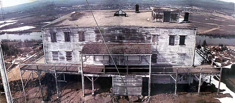
At the summit, remains of the Mt. Tom Hotel site, originally built in 1897, can be seen - but watch your step!
Here's the hotel in better days - the building site is now occupied by communications towers:

The Mt. Tom Hotel was the last of three mountain-top hotels in the immediate area.  We'll pass remains of the Eyrie House on Mt. Nonotuck later in this section, and the still-existing Mount Holyoke Summit House is across the river in the next section.  These were the great middle-class vacation spots for southern New England before everyone started flocking to beaches or taking cheap flights to Disney World in this past century.  Steamboats and later railroads brought tourists from the cities in Connecticut, NYC, Providence and Boston with relative ease.  Guests would either hike up or take horse-drawn carriages on cliff-side carriage roads up to the top.  Typical stays were for a week or more, and the hotels found themselves competing by offering concerts, dances, top-notch restaurants, croquet and lawn games, and other attractions.

 Even back then, visitors felt the urge to leave their mark.  I guess this is no longer graffiti since its old enough to be 'historic', but no matter - carving your name in hardass rock that's 100s of millions of years old is just plain cooler (and more permanent) than spray painting your idiotic tag name all over.  Lazy kids today. 

Apart from the fresh breezes and escape from summer heat, these places offered spectacular views over the pastoral farmland below and the ring of mountains around the valley.  In an era before airplanes and satellite photography, views like this were the only way to appreciate the enormity of the geography below:
This view (click to make bigger) is looking south from the summit of Mt. Tom.  The M&M trail runs atop the Metacomet Ridge, which is clearly visible in the right center, running almost due south into Connecticut.  Behind the tree on the far left is a partial view of Holyoke.  The city of Springfield and a portion of the Connecticut River is seen in the left half of the photo.  Hartford's skyline, 40 miles distant is hard to make out in the photograph but it was easily seen in person, on the horizon - directly above the blue watertower in the middle distance, which is above the lake in the near-ground.  On less humid days, you can even see the Hanging Hills near Meriden, Ct, south of Hartford, nearly 60 miles away from Mt Tom - the southern terminous of the Metacomet Trail in Ct!  Quite a view!


Looking north, we see the cliff side of Mt Tom, facing Easthampton, and the tilted slope of the basalt layer going gently down to the right.  Northampton is in the middle distance just to the left of the summit, while Amherst is the town seen in the distance through the gap to the right of the crest.  If you look carefully, on the horizon above Amherst is a distant lump - New Hampshire's Mt Mondadnock, 50 miles as the crow flies and the northern end of the M&M trail!!  Here's a closer look:
 Amherst on the left, and to the right, Mt Holyoke with the Summit House hotel on top.  And way far away: Monadnock, you monster! 

So from the top of Mt. Tom, one can see the entire 114 mile length of the M&M trail, as well as the length of CT's 63-mile Metacoment Trail.  In addition, you can see the tippy top of Massachusetts' tallest peak, Mt Greylock, in the northwest corner of the state and a few peaks in southern Vermont that I can't identify.  Four states, from a mountain that's only 1200ft tall.  Pretty amazing!


Continuing the excitement, after the summit,the M&M follows the cliff edges for about a mile, overlooking Easthampton with sheer drops hundreds of feet straight down:

I don't recommend setting up the camera with a delay and running along this edge in time for the shutter snap with a toddler on your back, but it does make for a nice shot:

The edge is not ever either, with several scrambles and squeezes.  Good thing basalt erodes in columns that make good steps:


After the cliffs, the trail dips down to a saddle between peaks, where there is a park access road and a holymoley, a playground!  (Is this not the best section??)  A welcome spot for peanuts who need a break.  And the playground is for real, pre-litigious, old school like I remember from my youth:  no plastic static electricity bombs, but all metal, Wisconsin iron!  Toddler swings with chains across an open seat front. A shiny sliding board that's both lightning fast and blazing hot from the sun.  They even have big see-saws, the kind where one kid would jump off and let the other kid slam down on his tailbone.  Nice to see.

The saddle also hosts the Reservation's visitor center, built by the Civilian Conservation Corp in the 1930s.  The CCC, as it was known, was a remarkable program of President Roosevelt's New Deal during the Great Depression.  It put young unemployed laborers to work building camps, trails, roads, bridges, erosion projects, fire towers, etc in the national and state parks and forests, teaching them skills and exposing them to nature at the same time.  Someone once told me that the federal funding for the program required that something like 85% go towards labor - I don't know if that's true or not, but certainly the projects that were built were all very labor intensive such as the hand-laid stone visitor center on Mt Tom:

I've hiked portions of the Appalachian Trail built by the CCC and the trails are still fantastically well-built.  Skyline Drive and the Blue Ridge Parkway, with their great bridges, and hundreds of miles of stone walls, still welcome tourists.  Its amazing to think that 80 years later, we are still able to enjoy this legacy of labor, done for purpose of creating national, not personal, wealth. 


The second half of this Section 6 wanders from the saddle up over two or three minor summits, each with excellent views.  Goat Peak has a firetower, with 360-degree views.  To the northeast, you can see the broad sweep of the entire Holyoke Range, which hosts the next three sections of the M&M.

The photo here shows the Connecticut River flowing from the left through the gap between Mt Nonotuck (dark green) and Mt Holyoke, with its white Summit House on top.  The other peaks form the Holyoke Range, with Mt. Norwottuck (in shade at the far right) anchoring the end.  The tall smoke stack is a coal-fired power plant on the river built in the 1960s.

Also fun in this section: walking down from the fire tower on open grate steps with a wriggling toddler on my back:

A brief side trail up the last summit, Mt Nonotuck, leads to the remains of another mountaintop hotel, Eyrie House.  While hiking, one tends to look down a lot to not trip, especially in deep woods like on this ridge, so you can imagine my surprise to look up and see this huge stone wall:
This was the foundation of what was to be the last iteration of the Eyrie House, which was originally built here in 1861.  It was probably the most successful of the area's hotels, since the Connecticut River directly below provided steamship access, and more importantly, the railroad was built on this side of the river.  At its largest, the Eyrie House was only 30+ rooms, but it entertained hundreds of people daily.  Promenades, viewing towers, picnic groves, a stable for 40 horses, a croquet lawn, swings, a huge outdoor pavilion (with roller skating!), clam bakes, bands, a menagerie of animals (including a bear, monkey, and alligator), and a very early telephone system all added to the attraction.  Unfortunately, in 1901, just as the summer season was about to begin, a cremation of a few dead horses got out of hand and the hotel, pavilion, and stable burned to the ground.  Patronage had been dropping anyway, and new competition from the Mt Tom Hotel doomed the idea of rebuilding.  The land was added to the reservation in 1904.

The last big vista on today's hike, from Nonotuck, overlooks the Oxbow, another landmark of the Valley.  It was once a tight meander of the Connecticut River, but a storm in 1840 allowed the river to push straight through, leaving this long C-shaped portion as a stranded lake (see the aerial at the start of this post).  In the view below, the Connecticut is just to the right of the frame, hidden by trees.  Interstate 91 cuts across the ends of the C.


At this point, the M&M descends from the ridge, using the carriage road that once led to Eyrie House.  In the 1879 view from the hotel seen below, you can see the road winding down, eventually turning into those tall hemlock trees, planted there to conceal views from ascending passengers until they popped out up top.

Those trees are still there, now huge!  Unfortunately they appear to be under attack by the woolly adelgid, which is a funny name for a very sinister insect that I will talk about in a later section.  For now, at least, the great trees still stand there lining the roadway, among the oldest trees on the entire range (since everything was logged at some point or another).

The trail pops out of the woods into a loud mess of civilization: giant overhead powerlines, houses with political lawn signs, busy surface roads, and an interstate highway.  A little roadwalking gets us to the official end of Section 6: the state boat ramp on the southern prong of the C-shaped oxbow, where an outlet to the Connecticut River is maintained. 
Looking east, under the Route 5 and railroad bridges, you can see the mighty Connecticut River, New England's longest.

If Vivi and I were thru-hiking, we'd have asked for a ride across the river from one of the two boating parties we saw here.  But we are not, and besides, the first boater was already pulling his fishing boat from the water onto a trailer, and the other group - two young Russian-sounding guys in a huge and expensive powerboat - appeared to be occupied with beers and bikini-clad women.  So, we turned around and walked the entire section back to our car, making for a very tired Peanut, and even more exhausted Dada.

At least the car ride home allowed Peanut to catch up on her reading:

Today: 6.3 trail miles, about 12 hiked miles.  M&M completed: 25.6 out of 114 mi.

Tuesday, October 2, 2012

M&M Section 5

September 6, 2012:  A 5.7 mile return to the hike-and-back means a long day.  But now north of US202, we are in land owned by Holyoke Community College and a sportsman's club, so its back to single-track trails (no more mountain bikes or ATVs).


OK, time for everyone's favorite subject: geology.  Imma drop some science!

I mentioned that the ridge we are following is basalt, with its origins as lava.  Which means the Connecticut Valley once had volcanoes!  Well, at least big cracks in the earth where lava seeped out.  How did this happen?  About 200 million years ago, the super-continent of Pangea began to pull apart, with long cracks or rifts appearing as North America and Europe/Africa separated.  One of these rifts eventually became wide enough to fill with ocean water and form the Atlantic - it's still spreading today and the Atlantic grows wider by about an inch every year.  Another of these faults  formed just to the west and opened wide enough to form the Connecticut Valley.  That fault - called the Eastern Border Fault because it runs along the eastern side of the valley - is still there, running between Keene, NH and New Haven, Ct and beyond, but hasn't been active for 10's of millions of years now.


It must've been very scenic when the valley was new - to either side were giant mountain ranges, and within the wide valley, plains and lakes and sandy beaches formed.  The Valley looked not unlike the rift valleys of East Africa, famous for their herds of elephants and wildebeests and lions, etc.   Only, the ancient Connecticut Valley had dinosaurs.  Their footprints appear on the shores of those lakes and can be seen in many places, including Holyoke and Connecticut's Dinosaur State Park.

The big footprint in the photo to the left is along Route 5 north of Holyoke and was made by a Dilophosaurus - remember the spitting dinosaur that gives it to Newman in Jurassic Park?

Over the course of millions of years, the valley filled with new rock layers.  A few times, the fault system oozed out hundreds of feet of lava covering large areas - that's the basalt we're walking on.  Still, the mountains on either side continued eroding and thousands of feet of new sediments soon covered the basalt.  Earthquakes along the fault tilted the new rock layers about 25 degrees, downward to the east.  But eventually all this activity stopped and the valley completely filled and the mountains on either side eroded down and everything in western Mass and Ct was a level plain.  Except Mount Monadnock, which continued to poke up above everything just as it does today.  More on that tough mound of rock later.

More recently, rivers and glaciers re-formed the Connecticut Valley, eroding the soft sedimentary rocks to form the low wide valley we know today.  The hard roots of the ancient mountains on the side of the valley now form the Berkshires and the mid-state highlands.  And the edge of that layer or two of hard basalt, because of the tilting from long ago, now pokes up above the valley floor too, forming our ridge and giving it the distinctive cliffs on the western side and gentle slope to the east.

Let this sign from the Mt Tom visitors center show you - i drew the M&M in red.  The current section is just below where this cutaway drawing starts:


Ok, enough science!  The hike in this part was delightful despite the cloudy weather - several views and great deep woods that feel very remote despite being mere miles from Holyoke and its suburbs.  Here's a shot looking south, where you can see the eastern gentle sloping side of the ridge (that 25% tilt) and the western cliff side, especially on that far hill from Section 2: 


Hiking in New England, one often comes across random giant boulders like we did, called an erratic:
This guy, which isn't basalt like the rocks it is sitting on, traveled with the giant ice sheet that once covered the northern part of the US.  He was plucked up somewhere well north of here and left at this spot as the ice melted from under it.  National Geographic just had an interesting essay about erratics a month or so ago, with this nice shot of Glen Rock in Glen Rock, NJ.


OK, FOR REALZ, NO MORE GEOLOGY.  Though, it is kinda cool.

 Today: 5.7 trail miles.  M&M completed: 19.3 out of 114 mi.